|
Bihu Loukon
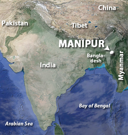
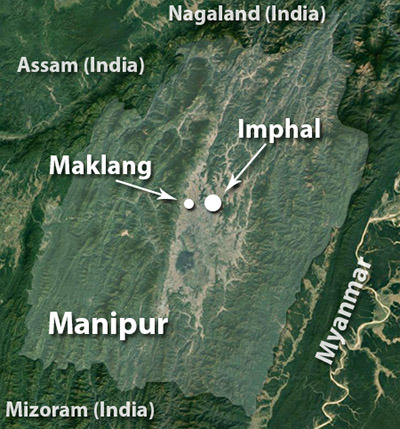
Maklang, Manipur, India
|
|
 |
Constructed: ???
Used by: ???
Conflicts in which it participated:
???
|
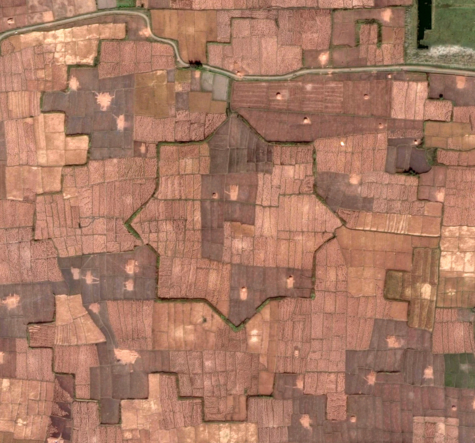
Just a smidgen to the west of the teeny town of Maklang in the state of Manipur, India, sits the remains of the mighty Bihu Loukon, a mud-walled, eight-pointed starfort. Which concludes the factual information we have about this starfort! Thank you for reading, goodnight!
Well, there's a little more information to be had about what was clearly once a stellar starfort. It was introduced to the wider world in 2013, when a Google Earth peruser spotted the fort's outline and reported it to the Kangla Fort Board, an organization dedicated to the history and maintenance of the Palace of Kangla, the traditional seat of government for the Kingdom of Manipur, in the city of Imphal. |
|
 |
|
The locals, of course, knew a little something about this fort. When questioned by a journalist from Kangla Online, one elderly gentleman referred to Bihu Loukon as the pallis, and said that its walls had been higher when he was a lad. He described a long canal connecting the fort to local waterways, upon which boat races had been held. What the locals did not know was that this had been a starfort! It is difficult to see the shape for what it is from ground level, and they were shocked and amazed to see the satellite imagery...although they were probably even more shocked to learn that there are such things as "satellites." Today, the fort's mud walls are about five feet high, and about fifteen feet thick. The entire fort is described as encompassing "five or six hectares," which would make it somewhere in the neighborhood of 538,000 or 646,000 square feet. By comparison, Fort Adams in Newport, Rhode Island is the United States' second-largest fortification, and is just over 871,000 square feet. Bihu Loukon was enormous! |
 |
|
Officials on the scene speculated that this fort must have been built very long ago indeed, as the walls are demonstrably mud, with no bricks in evidence...perhaps even older than Kangla Palace itself, which dates back to the 1630's. Maybe, but in my experience abandoned forts tended to be treasure troves of free building materials for the local populace, so bricks may have been used, and then carted away once the garrison left.
And the shape of the fort itself is a mystery. The concept of the starfort emerged in northern Italy at the very end of the 15th century, in reaction to cannon being increasingly used in siege warfare. Everybody in Europe was swiftly enamoured by this fortification design, and examples began to pop up all over the place...but in the middle of Asia, just 100 years after the concept was invented many thousands of miles away? |
|
|
Unless the shape in which Bihu Loukon was built was chosen solely for esthetic purposes, it would almost have to have been built in the late 18th or 19th century...when somebody armed with cannons was in the region, cannoning merrily about, and the fort's defenders had cannon of their own to mount in such a defensive structure.
The remains of Bihu Loukon's jigsaw-like outer wall are also interesting. Was there really a thin wall with such irregular lines surrounding the fort, or are these the foundations of a more wall-like wall? And, ultimately, why was this vast fort placed here, in the middle of countless acres of paddy fields? Certainly not to defend such a tiny sliver of a town like Maklang, which probably hadn't existed when the fort was built in any case.
|
Today one of India's most far-flung states, Manipur has been part of a well-travelled trade route betwixt India, China and Southeast Asia for over two point five millennia. The Kingdom of Manipur was sucked into the First Toungoo Empire in the late 16th century, an empire which comprised most of modern Myanmar, Thailand and Laos. This empire began to dissolve soon after its ruler and driving force, Bayinnaung (1516-1581), died...but Manipur remained on the outskirts of Burma (today's Myanmar), and was swept along in the wake of that troubled land.
Formerly being part of an empire is kind of like previously having dated a particularly jealous and, as you have belatedly realized, dense mate. You know that the relationship is over, but somehow this is not as clear to Aggressive Mate, who feels as though it's only a matter of time until you're safely back in their arms.
Over the next few centuries, successive rulers of Burma did what they could to bring the Kingdom of Manipur back into the fold through a series of military adventures and dynastic marriages. Little Manipur stood fast, however, and remained more or less independent.
|
|
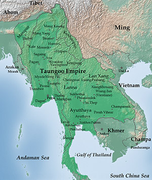 The First Toungoo (Taungoo?) Empire at it's greatest extent, in 1580. Look to the upper left for spunky lil' Manipur. Thanks for your excellence in all things, Wikipedia! The First Toungoo (Taungoo?) Empire at it's greatest extent, in 1580. Look to the upper left for spunky lil' Manipur. Thanks for your excellence in all things, Wikipedia! |
|
And this is the likely reason that Bihu Loukon was built where it was...it sits about 10 miles directly to Imphal's east, along a road what would surely have been a likely route of invasion for those who wished Manipur ill. While this is not the most direct route from Burma as the crow flies, Manipur is mostly mountains, with a 700-mile-wide, ovular valley nestled in its center. Any force approaching directly from the east or west would rapidly exhaust itself clambering over endless rocky terrain, so snaking from the north our south, while also a lengthy and painful process, seems to be the only logical course of action for militaries without helicopters.
In the case of a north- or southbound attack into the valley, the notional (Burmese) invading force would probably hang a right (or a left, if coming from the north) at Maklang. Hence, Bihu Loukon.
|
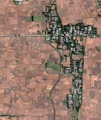 The wee townlet of Maklang, and Bihu Loukon. You might need to squint to see it! The wee townlet of Maklang, and Bihu Loukon. You might need to squint to see it! |
|
If Bihu Loukon was built to defend an expected route of attack towards the Palace of Kangla, Manipur's capital at Imphal, it seems unlikely that it would have been the only such fortification built for this purpose...but as neglect and aggressive farming has nearly erased the Starfort Of Our Current Interest™ from the earth, it seems likely that other, similar forts have been ploughed under and long forgotten.
With the why at least partially answered, we turn back to the when.
While it is of course impossible at this point to know when Bihu Loukon was built, archaeologists involved in researching the fort when it was first "discovered" in 2013 mentioned the possible use of radiometric dating. This process could conceivably identify the "exact date" on which the mud used in the fort's construction was first exposed to sunlight. Which sounds delightful, but it doesn't appear that any further information regarding Bihu Loukon has been published online since the initial rush of local excitement when the fort was identified in 2013. |
|
|
If we agree that the shape of Bihu Loukon denotes the use of (or recognized need for defense against) artillery, we must wonder how and when "modern," European-style artillery might have made its appearance in the region.
In 1599 the ever-expansionist Portuguese, in the person of mercenary Filipe de Brito e Nicote (1566-1613), commanding three frigates and 3,000 men, managed to capture the port city of Thanlyin. On the Gulf of Thailand, this had long been a major port of the Toungoo Empire, and though that empire was disintegrating by the start of the 17th century, King Anaukpetlun (1578-1628) managed to get his empirical act together and recapture the city in 1613, executing Brito by impalement.
|
Did this clash with the Portuguese introduce the joys of "modern" artillery to the Toungoo Empire? If so, the locals got over their shock in a hurry and made relatively short work of Brito's force...plus, the Toungoo Empire continued on its downward spiral, so it seems unlikely that King Anaukpetlun had appropriated some revolutionary new weapon from his experience with the Portuguese.
The French East India Company took over Thanlyin and made it their base of operations in the region in the 1740's, providing arms to yet another local empire, the Hanthawaddys, in their ongoing war against the Konbaung Empire for control of Burma. Never ones to willingly be left out of a fracas, the English East India Company also got involved, eventually providing arms to the Konbaungs. Modern cannon! Did either European entity also provide starfort instruction to anyone? Even if so, the areas in which the French and English operated at this time were very far from Manipur.
The colonial tendrils of Great Britain had slid inexorably closer to Manipur by the 1820's. |
|
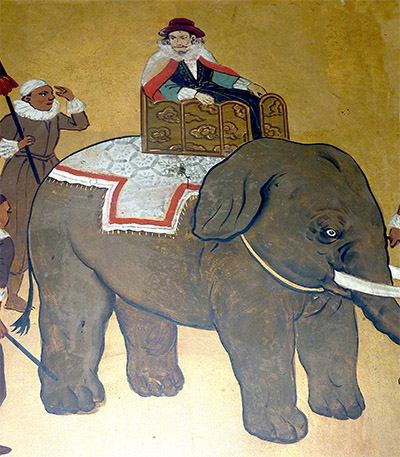 Portuguese mercenary Filipe de Brito e Nicote, in his carefree pre-impalement days. And a charming elephant that one hopes was not also impaled. Because no elephant chooses to have guys ride around on its back. Portuguese mercenary Filipe de Brito e Nicote, in his carefree pre-impalement days. And a charming elephant that one hopes was not also impaled. Because no elephant chooses to have guys ride around on its back. |
|
|
This put them at odds with Burma, which had been doing its best to recapture Manipur for the past decade. The First Anglo-Burmese War (1824-1826) ensued, which resulted in the manner one might expect, given the hindsight of history. With the British now calling most of the shots in the region, Manipur was eventually annexed along with the rest of the Indian subcontinent by the end of the 19th century. Could Bihu Loukon have been built during this period, as a last-ditch effort to keep the British out of Imphal?
|
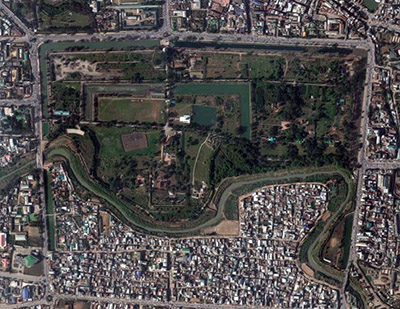 Kangla Fort in Imphal, Manipur: Just about as much of an un-starfort as is possible for a fort to be. Kangla Fort in Imphal, Manipur: Just about as much of an un-starfort as is possible for a fort to be. |
|
Manipur was permitted semi-autonomy as a "Princely State" within the British Raj. Japanese forces attempted to bash their way to Imphal during the Second World War (1939-1945). Imphal had been built up as a major Allied logistics base, with airfields and supply dumps, both of which would have been extremely useful for the Japanese as their fortunes were turning against them in 1944.
Fierce and costly fighting raged from March until July of 1944 betwixt the Japanese and combined British, Indian and Gurkha forces, just about everywhere around Imphal except to its west, which means that Bihu Loukon was unlikely to have been even tangentially involved. Ultimately, the Japanese were denied their goal. |
|
|
Manipur today remains in relative turmoil, with several groups violently agitating for various forms of independence. The Indian government considers the state to be a Disturbed Area, which pretty much means that it's under martial law. All of which is extremely interesting, but gets us not an inch closer to understanding the true nature of Bihu Loukon. It was a starfort that may or may not have been constructed with the true intention of being a starfort. Unless and until information is revealed relating to this fort's date of construction, everything we say about it is rash speculation. You'll have to admit, however, that I've done a pretty spectacular job of saying little more than "I don't know" throughout this lengthy writeup! A bazillion thanks to Jacob Bogle, mastermind of the awesome Fortress Earth project, for bringing Bihu Loukon to our attention!
|
|
|
|
|
|
|