|
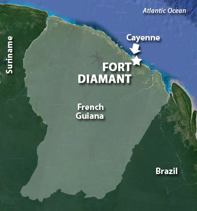
Fort Diamant
Rémire-Montjoly, French Guiana
|
|
 |
Built: 1840-1849
Used by: France
Conflicts in which it participated: None
|
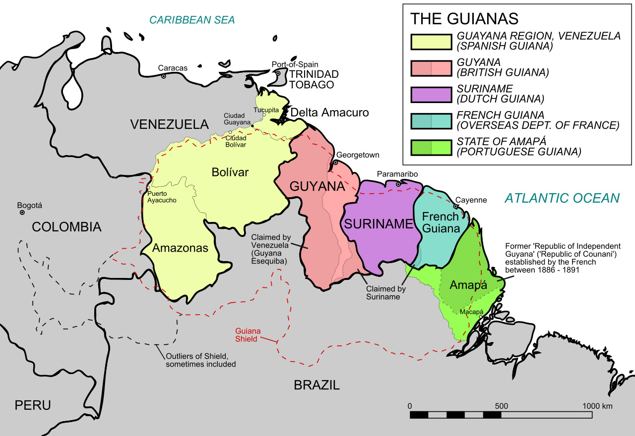
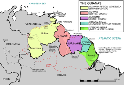
In the starfort-studded Age of Discovery, Europe's maritime powers often focused on relatively small stretches of overseas coastline, where they elbowed each other mercilessly in order to gain unfettered access to the unexplored continent's riches. In Africa this was the Gold Coast; in South America it was Guiana.
Our old pal Christopher Columbus (1451-1506) is credited with being the first European to set eyes on this particular coastline, in 1498. Portugal, the Netherlands, Spain, France and England all made numerous attempts to colonize the northwestern part of the South American continent beginning at the dawn of the 16th century, with the Dutch being the primary early settlers. |
|
|
|
The little island at the mouth of the Cayenne River must have seemed a good place for an easily defensible bastion of colonization, but the Spanish passed on it, feeling the weather to be too unpleasant and the land too poor. The French showed up in 1604 and decided it wan't that hot, and planted a colony on the island. The Portuguese were having none of this nonsense however, as according to the tenets of the Treaty of Tordesillas* (1494), they owned the South Atlantic Ocean, and were perfectly happy to commit murder and mayhem to enforce their ownership. A little bit o' murder 'n' mayhem later, the tiny French colony had ceased to exist.
|
 Very informative! Thx, Wikipedia! Very informative! Thx, Wikipedia! |
|
Word must have gotten back to France that this little island was a pretty cool (if hot) place, because a second wave of French colonists returned in 1643 and thereupon established the town of Cayenne, which is today's capital of today's French Guiana. Local Kali'na chief Sépélu** graciously ceded (or perhaps sold) land to the French, atop which a wooden fort was duly built.
This fort would be torn down and rebuilt several times, but forever bore the name of the man who had made it possible, sort of. The French, who must have had a hard time understanding Sépélu's accent when he introduced himself, called their fort, and the hill it was built on, Cépérou.
|
|
|
Around 1650, the French built some semblance of a wooden fort at the mouth of the Mahury River, about five miles down the coast from Cayenne. It's hard to look at the map today and determine why anyone, French or otherwise, would feel that the mouth of the Mahury River would need to be dominated by a coastal fort...but the river does wind over a hundred miles inland, and assumedly there was something in there that the French valued. There were plans to make the wooden fort into a real fort, i.e. one made of stone, but getting building materials delivered to this part of the world was understandably difficult...and as it turned out, the local Indians ultimately weren't any happier with a French presence than the Portuguese had been, and the French were chased out of nearby Cayenne again before they could get serious about the wee fortlet on the Mahury...which may or may not have been known as Fort Diamant at that point. But it is now!
|
When the French returned to Cayenne a third time in 1664, they came to stay, but first they had to get past the town being recaptured by the Dutch (who called the fort Bourg Louis when they owned it) and then the English (who called it Fort St. Michael during their administration of Cayenne) over the following decade. Once those small hiccups were cured, the French wisely went all in on their South American colony...because clearly if they didn't, somebody else would just sail in and take it over again (perhaps Norway might have liked to take a whack at it, for example).
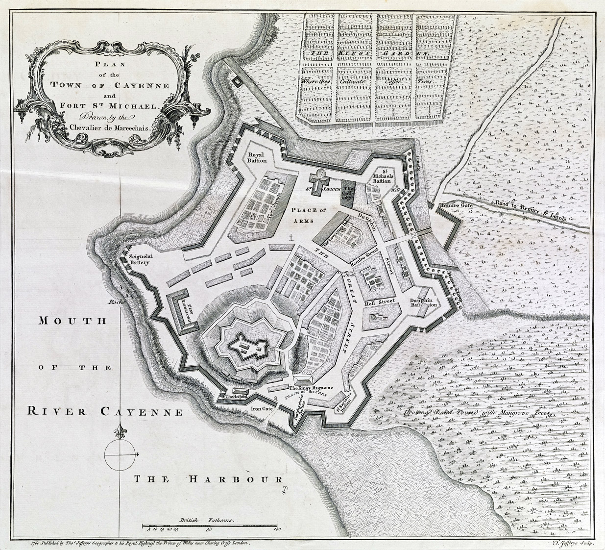
From 1689 to 1694, the French surrounded Cayenne with the loveliest examples of starfortery that were possible in the late 17th century, which statement is absolute objective fact, in that the town's defenses were designed by none other than the Father of the Starfort himself, Vauban (1633-1707).
|
|
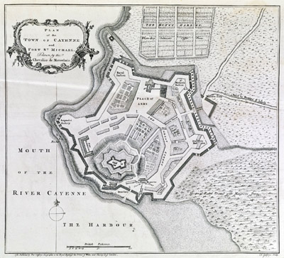 The breathtakingly Vaubannian fortified city of Cayenne in 1760. The breathtakingly Vaubannian fortified city of Cayenne in 1760. |
|
Vauban was France's Commissioner General of Fortifications under King Louis XIV (1638-1715), and there is no more hallowed name in the history of starforts. There were starforts both before and after Vauban, but he's the one who got 'em as right as they could get.
As far as I can tell in my usual halfassed research, Vauban never actually went to South America, so his plans were made from a distance of 4,400 miles. One of the things that made Vauban's starforts so distinctively excellent was that they took the lay of the land into account, and used the local features to their advantage...so whomever supplied Vauban with the maps he would have needed to design a such an extensive fortification from such an extensive distance must have been on top of his game.
Once protected in the loving embrace of starfortification, Cayenne spent a century safe from anything the outside world could throw at it until, perversely, Napoleon (1769-1821). The Tiny Tyrant blessed so much of the world with reason and enlightenment (frequently by killing people) that the world eventually united to defeat him and France, without which he would have just been an angry short guy. Napoleon's many victories on land weren't replicated at sea, and the French Navy was soon bottled up in port, with the Royal Navy blockading it securely in place. This left France's far-flung colonies undefended, and Cayenne found itself under blockade in the early years of the 19th century.
|
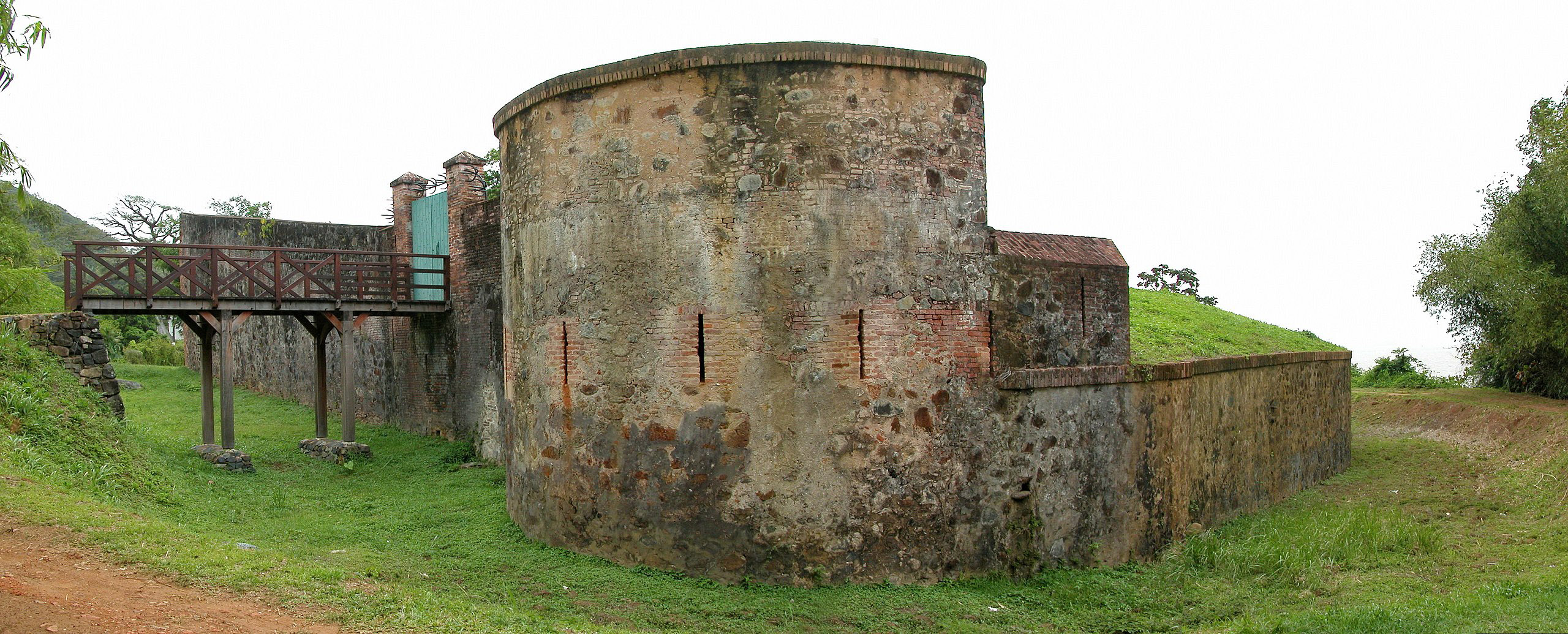
 The western side of Fort Diamant. The western side of Fort Diamant. |
|
England's Royal Navy was stretched to the limit in this conflict, and thus proposed a joint operation with the Portuguese, whose government had conveniently relocated to Brazil in 1808 due to the French invasion of Portugal, to wrest Cayenne from the French. The Portuguese and British were able to scrape together some 550 soldiers and four ships for this operation, which everyone agreed would not be enough to capture Vauban's fortress in a siege. |
|
|
Fort Cépérou was by now supported by a series of other strategically-placed fortlets, with Fort Diamant being the most substantial. Recognizing that these supporting forts had to go before Cayenne could be assaulted, the Portuguese landed five canoes' worth of seamen and marines at Point Mahury on January 7, 1809, in the wee hours of the morning. The nearby Dégras de Cannes battery was assaulted at the same time, and both works were captured, along with 90 French soldiers.
When the Governor in Cayenne sent 600 troops out to take these positions back, the British and Portuguese destroyed Fort Diamant. Though outnumbered, the plucky British and Portuguese force outmaneuvered the French, locating and defeating a few more of Cayenne's outlying batteries, and the weakened and starving Cayenne garrison surrendered the town and its stellar starfort on April 14, 1809. Portugal folded Guiana into Brazil at that time, with the agreement that 'twould return the colony to France after the war.
|
If you were left in charge of a mighty fortification that your enemy had built, understanding that you would be handing it back to that enemy in the near future, what would you do to that fortification? Well, that's exactly what the Portuguese did to Cayenne's fortifications from 1809 to 1817: Demolished them!
Imagine how thrilled the new French garrison must have felt, sailing to Cayenne in 1817 after their monarchy had been restored, eager to reclaim their South American colony and its world-class starfort! And imagine their reaction to the pile of rubble that awaited them. |
|
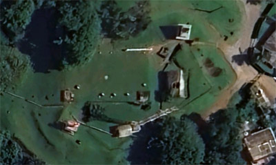 What's left of Fort Cépérou, Cayenne's mighty fortress, today. What's left of Fort Cépérou, Cayenne's mighty fortress, today. |
|
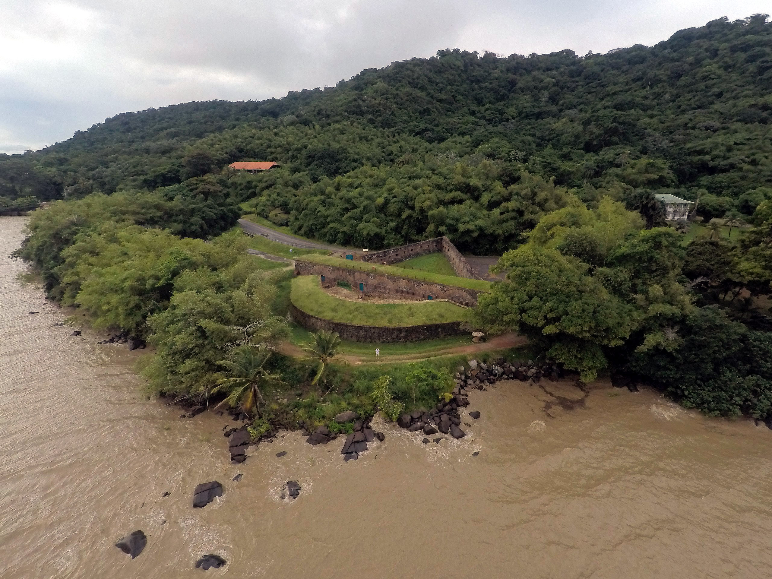
It must be said that, whatever their motivations, the Portuguese did an excellent job of doing away with Fort Cépérou and the rest of Cayenne's fortifications, which today is represented by a small huddle of earthworks, low walls and a few ramshackle structures. Fort Diamant, by comparison, has weathered the years much more impressively.
|
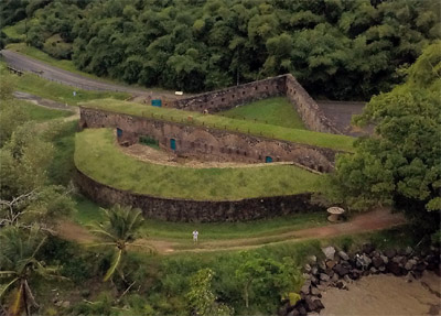 The western side of Fort Diamant. The western side of Fort Diamant. |
|
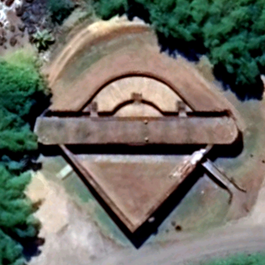
...because it was actually rebuilt! The French began constructing a newer and better Fort Diamant in 1840, on the spot where the original once stood at the mouth of the Mahury River. A relatively simple affair that mounted three guns on an upper level, five on a lower level and what is essentially a loopholed redan pointing inland, this arrangement seems remeniscent of Fort Barrancas in Pensacola, Florida, with the rounded battery facing the water and angled work protecting the rear. Construction of this moated, basalt rubble and brick fort took nine years, once again owing to the difficulty of transporting building materials to the area. |
|
|
The pretty new Fort Diamant was never to be challenged. French Guiana became France's primary place to dump its undesirables after the Louisiana Purchase of 1803 gave most of its North American lands to the new United States. The infamous Devil's Island prison complex, on three islands just off the coast about 20 miles northwest of Cayenne, operated from 1852 to 1953.
According to comments written by folks who have investigated Fort Diamant in recent years, it never seems to be open to visitors, and there is no informational signing. One person complained that there's no explanation as to how Fort Diamant got its name...which seemed silly, because the thing sure looks like a diamond to me, but there's no telling how long forts at that spot have been called Fort Diamant, and the fort's initial incarnation may have looked more like a box or a hedgehog or something.
Many thanks to French Guianan resident Anais Boinega, who alerted us to Fort Cépérou, and by extension Fort Diamant!
|
|
|
|
|
|
|