 |
Handyside Fort
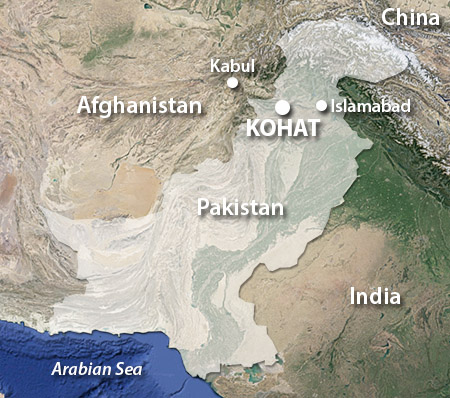
Kohat, Pakistan
|
|
 |
Constructed: 1853
Used by: Great Britain, Pakistan
Also known as: Fort Mackeson,
Kohat Fort
Conflict in which it participated:
Various colonial miniscuffles
|
Handyside Fort was built in what has historically been a particularly nasty part of the world, just south of the Khyber Pass. This is a mountain pass connecting Pakistan with Afghanistan, through the otherwise unnavigable Spin Ghar mountains. Military forces led by such long-ago superstars of invasion as Persian Darius the Great (550-486BC) and Mongol Genghis Khan (1162-1227) used the Khyber Pass as their route to glory.
Tribes in what is today Pakistan spent many blissful years squabbling amongst each other as part of the Mughal Empire (16th-19th centuries), sadly unaware of the existence of starforts. |
 |
 |
|
The benevolent, civilizing influence of Great Britain appeared on the Indian subcontinent in the earlyish 17th century, in the form of the East India Company. Forever battling their Portuguese and Dutch equivalents for ascendancy in the spice trade, the EIC slowly clawed their way to the top of the trade heap in India, and when the influence of the Mughal Empire was waning in the 18th century, the EIC was right there to fill the governmental void.
|
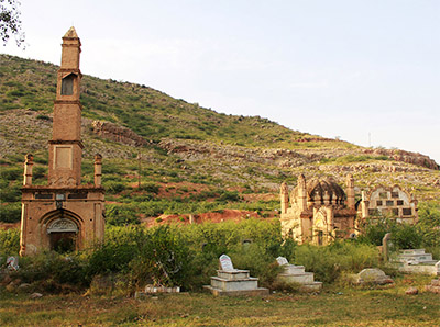
 There are precious few pictures of Handyside Fort available online...in fact there are exactly zero that I could find! This may have something to do with the fact that the fort is still on active duty with the Pakistani Army, although the hope of keeping the design one's otherwise extremely well-documented 19th-century walls from the prying eyes of those who might wish to do the Pakistani military harm seems a thin reed indeed. This is the #1 image that comes up in relation to Handyside Fort. What I think we're looking at here is the fort's cemetery? Sound reasonable? We'll go with that then. |
 |
The British soon learned that in order to project power in such a mountainous region, it's all about the passes. In their effort to build a network of roads o'er which they could transport themselves and their stuff, the EIC discovered that the Kohat Pass was a necessary stepping stone to the Khyber Pass, and began to pave accordingly.
The many hill tribes of this area, who had been happily hacking at one another for a thousand years, did not take kindly to the new kid on the block. EIC working parties were ambushed and cut down, which naturally led to a series of vicious reprisal raids, some of which were led by Lieutenant Colonel Frederick Mackeson (1807-1853).
Assigned to pacify the pugnacious frontier tribes in 1851, Mackeson did such a good job that a price was placed on his head, and he was stabbed to death on September 10, 1853 by "a religious fanatic."
|
|
|
It is at this point when the narrative of Handyside Fort breaks down. While there are zero actual pictures of the starfort of our current interest available on the Internet, there is only slightly more than zero information about its history. My personal sleuthing leads me to believe that what is today Handyside Fort was originally Mackeson Fort, constructed by the British Indian Army the early 1850's in order to provide a strong base of operations for military action around the Kohat Pass, and that Frederick Mackeson's death provided not only a convenient name for the fort, but additional impetus for its construction.
|
Another driving force for the Fort That Would Be Handyside was Colonel Robert Napier (1810-1890). Through a long and illustrious career, Napier was as one of Queen Victoria (1819-1901)'s colonial troubleshooters, serving in India, China and Africa and ultimately being named Governor of Gibraltar in 1876.
'Twas Napier who chose the site for our fort, at which stood the crumbling ruins of a fortification left over from the Durrani Empire, which had battled with the Mughals in the 18th century. Purportedly, it was atop this particular hilltop that none other than Alexander the Great (356-323BC) camped with his army in 326BCish, whilst heading north to do Alexanderian things, such as kill lots of people and conquer large areas.
|
 |
Kohat Pass, as viewed from what would eventually be named Handyside Fort, in 1924. |
|
If our fort was indeed originally Fort Mackeson, it lived an interesting life of betrayal and rescue. On at least one occasion the garrison, a detachment of "the 24th N.I." (Northern Ireland? Nefarious Indians?), made a deal to surrender the fort to a local tribe called the Affridis, in return for safe passage through the hills. Their cockamamie scheme was foiled by a Colonel Edwardes, who was later praised for not bothering any "European" troops with this nonsense, instead utilizing 25 "native levies" to secure the fort from the wicked plotters.
|
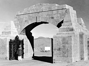
  Handyside Gate, gateway to the Kohat Pass. Handyside Gate, gateway to the Kohat Pass. |
 |
The British East India Company transferred power over India directly to the British Crown in 1858, after the vastly bloody Sepoy Mutiny had illustrated that the EIC's rule was insupportable. Over the next several decades a town formed around our fort, which would have improved the lot of the fort's garrison by way of providing easy access to goods and services, but probably also made things much more aromatic, likely not in a good way.
Preventing all those hill tribes from doing things the British didn't want them to do proved to be difficult for the British Army, so in 1913 the Frontier Constabulary (FCm) was formed. This was an armed police force that operated betwixt settled society and the hill tribes, and occasionally assisted the army in its endeavors.
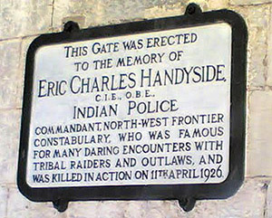
Eric Charles Handyside was the FCm's commandant from 1921 until 1926, in which position he undertook many two-fisted, rough 'n' tumble adventures. Handyside's heroic doings ended on April 11, 1926, when he was shot to death while trying to make an arrest. Somebody in authority must have thought Handyside was a pretty great guy, as not only was the Handyside Gate built in 1926, gateway to the Kohat Pass, but Fort Mackeson, which stands next to this gate, was renamed for him. Presumably nobody remembered who Mackeson was 70 years after his passing anyway.
|
|
|
Pakistan finally became a nation unto itself in 1947, when the British Raj officially ended after 89 years of fun 'n' games on the subcontinent. Today Handyside Fort remains on active duty, as headquarters for Pakistan's 9th Infantry Division, which is part of the XI Corps based in Peshawar. There aren't a whole lot of starforts out there with their own helicopter landing pad! Handyside is well-placed to keep an eye on the Afghan border. One assumes that it is so difficult to find pictures of Handyside Fort today due to its current military status. I found Handyside Fort thanks Jacob Bogle's spectacularly stellar Fortress Earth project. Thanks-a-plenty, Jacob!
|
|
|
|
|
|
 |


